
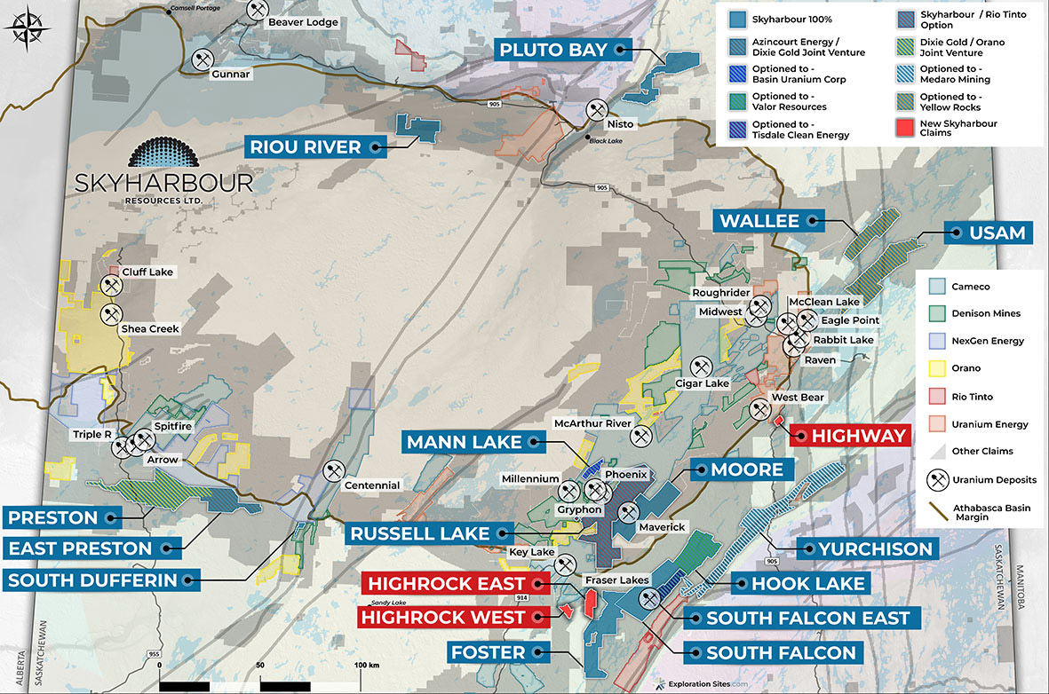
Skyharbour’s New Uranium Project Portfolio Map:
https://www.skyharbourltd.com/_resources/maps/SKY_NewProjects_Locator_20211209.jpg
Highlights:
- Riou River Project – 18,227 ha along the Riou River within the Athabasca basin, contains over 40 km of discrete undrilled EM conductors along a magnetic low and anomalous boulder geochemistry.
- Pluto Bay Project – 28,840 ha northeast of Black Lake hosting numerous uranium showings and several EM conductors east of the regional Black Lake fault.
- Wallee Project – 20,765 ha about 35 km northwest of Cameco’s Eagle Point Mine, numerous untested EM conductors coinciding with significant magnetic and/or gravity lows in the Wollaston Domain.
- Usam Island Project – 42,186 ha approximately 21 km northeast of Cameco’s Eagle Point Mine, contains numerous EM conductors situated along significant magnetic lows of the Wollaston Domain.
- Foster River Project – 37,529 ha southwest and adjoining Skyharbour’s South Falcon Point project, numerous uranium showings including up to 1.25% U3O8 in grab samples.
- South Dufferin Project – 922 ha along the trend of the Virgin River Shear, which hosts Cameco’s Centennial high grade uranium deposit 32 km to the north.
Jordan Trimble, President and CEO of Skyharbour Resources, states: “We have been actively staking claims and adding to our dominant uranium project portfolio in the Athabasca Basin. These newly acquired projects are strategically located and are geologically prospective with very little modern exploration having been carried out on them. They complement our more advanced-stage exploration assets including Moore Lake and South Falcon Point, and provide additional ground to option or joint-venture out to new partner companies as a part of our prospect generator business.”
Summary of Properties:
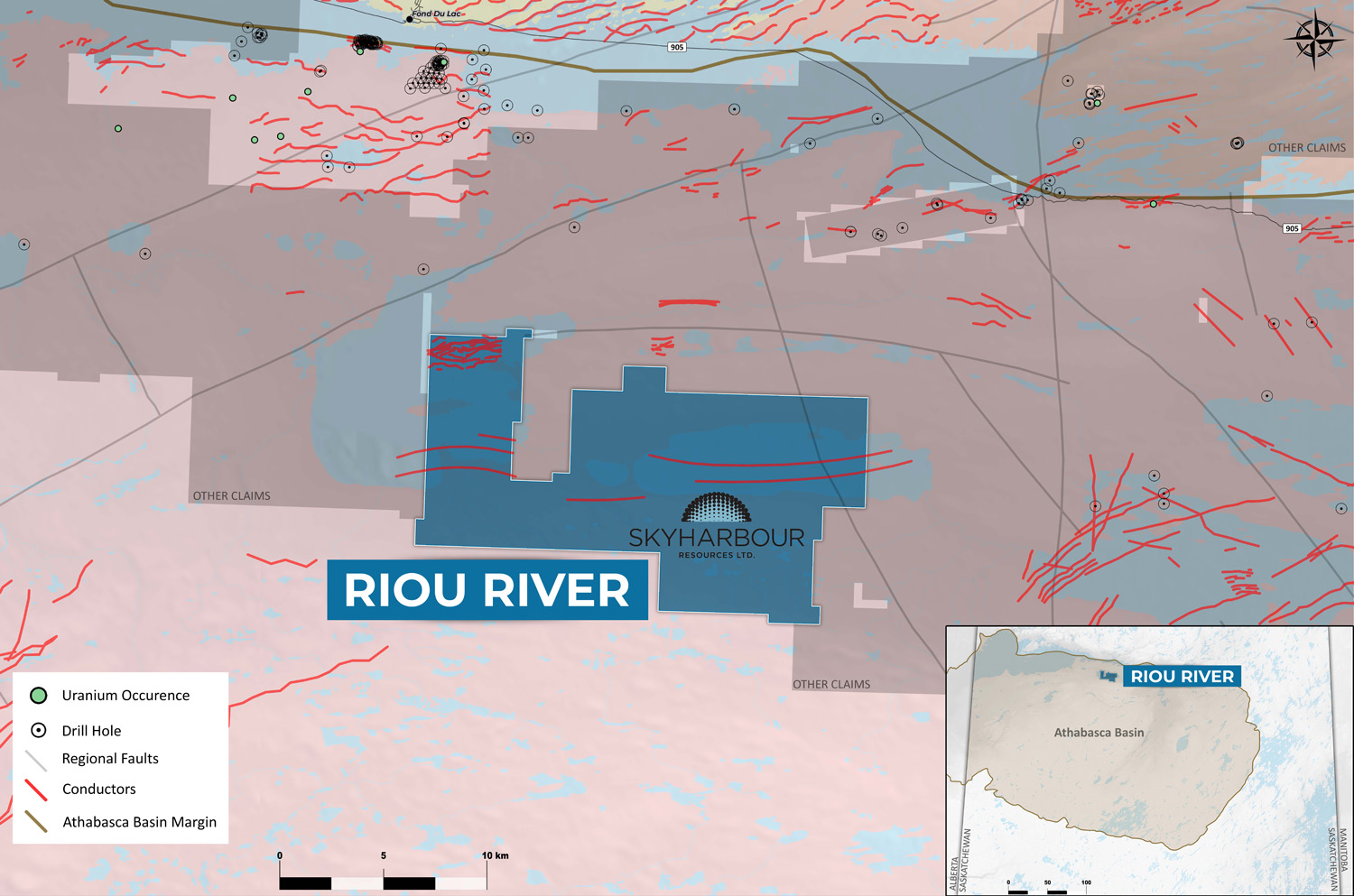
Riou River Project:
The Riou River Project comprises 18,227 ha along the Riou River located entirely within the Athabasca Basin. The sandstone is estimated to be 200 to 300 metres thick in this area and overlies basement rocks of the Archean-aged Tazin Gneiss Group. The property lies south of a significant east-northeast trending magnetic lineament, indicative of significant crustal offset in this area. There are several discrete EM conductors totalling nearly 40 km on the property alongside magnetic lows and coinciding with geochemically anomalous boulders. A major swarm of EM conductors of unknown significance also exist on the northwestern extent of the property. Historic exploration on nearby claims immediately to the north of the property identified sandstone and outcrop occurrences ranging from 72 to 375 ppm U, 3 to 7 ppm Th, and 8.24% P2O5. These values in sandstone are considered geochemically significant for uranium exploration. It should be noted that the property has never been drill tested.
Riou River Project Map:
https://www.skyharbourltd.com/_resources/maps/Sky_RiouRiver_20211209.jpg
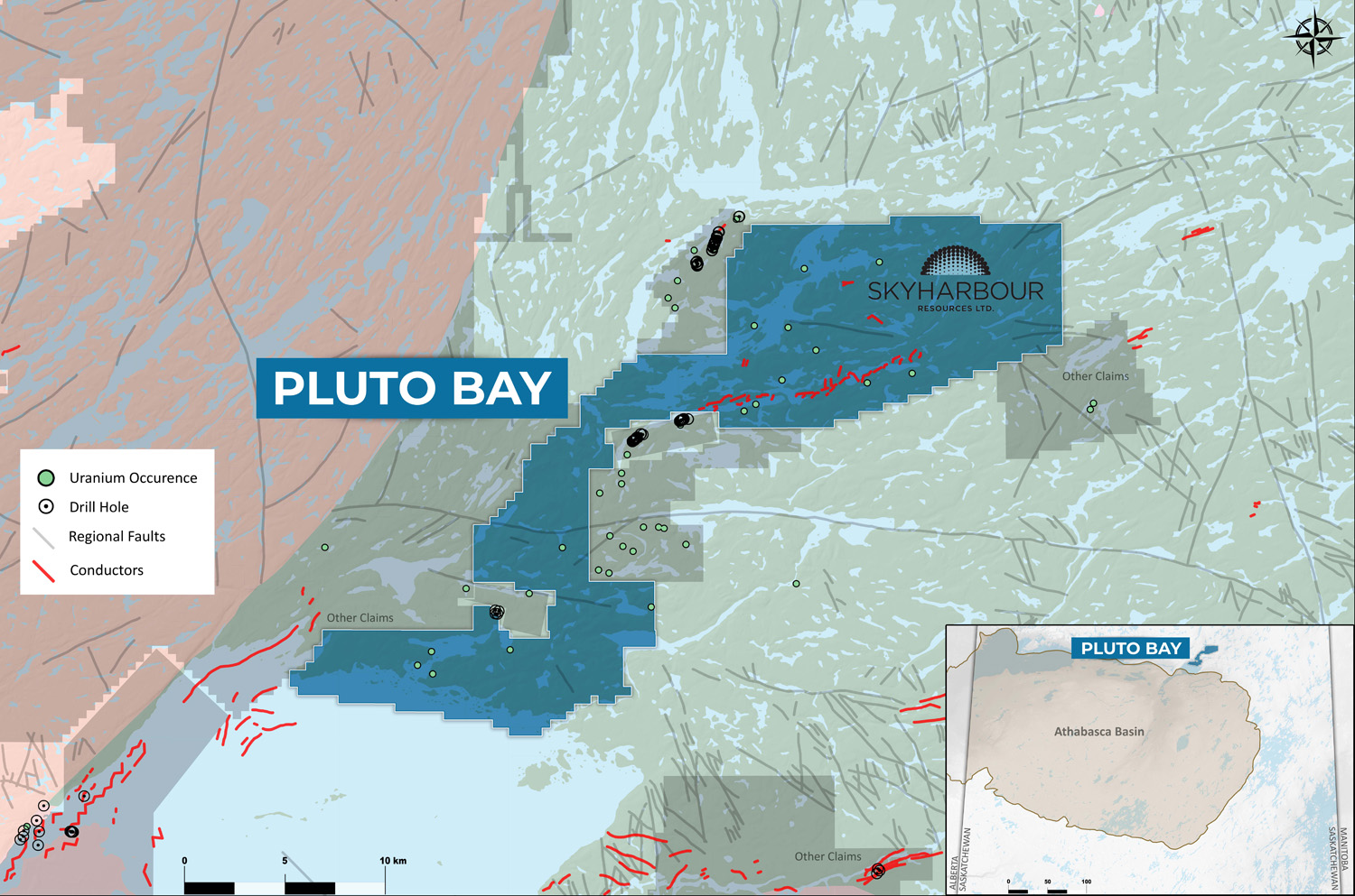
Pluto Bay Project:
The Pluto Bay Property consists of 28,840 ha northeast of the communities of Stony Rapids and Black Lake. The property lies just outside of the Athabasca Basin within rocks of the Trans-Hudson Mudjatik Domain. This property hosts numerous uranium showings within prominent magnetic lows that appear to be subsidiary structures to the regional Black Lake fault. The underlying rocks on the property have been mapped as felsic intrusive rocks along with metasedimentary and amphibolite gneiss units. The northern portions of the project are located northwest along strike of the historic Charlebois Lake uranium deposits where uranium values of up to 1.57% U3O8 were identified historically. Irregular, discontinuous EM conductors flank the showings that were identified in this area. The property has lain largely unexplored since the mid-1970’s and as such has not seen any exposure to modern exploration methods, especially geophysics and geochemical sampling programs.
Pluto Bay Project Map:
https://www.skyharbourltd.com/_resources/maps/Sky_PlutoBay_20211209.jpg
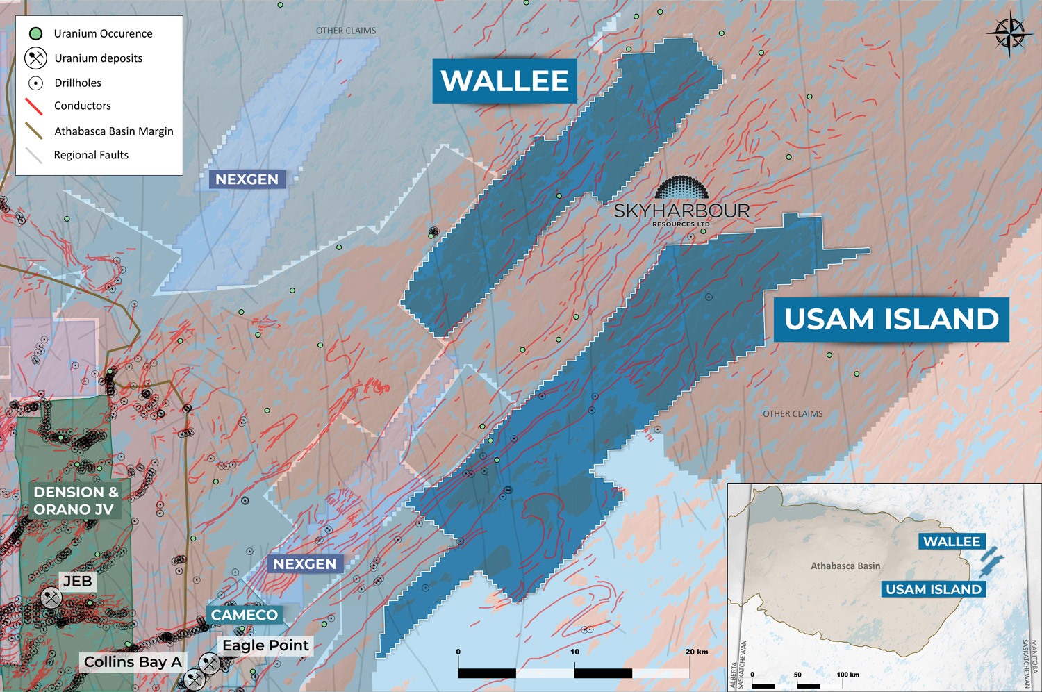
Wallee Project:
The Wallee project contains approximately 20,765 ha in four claims 35 km northeast of Cameco’s Eagle Point Mine (Rabbit Lake Operation). The project is underlain by Wollaston Supergroup metasediments, including highly prospective graphitic pelitic gneisses, as well as Archean granitic gneisses. The project lies outside the currently mapped extent of the Athabasca Basin sandstone; however, several small outliers of sandstone have been found in the surrounding area which indicate the Basin extended over this area in the past. Multiple untested EM conductors are present on the property that coincide with magnetic and/or gravity lows, which are locally disrupted by faulting including multiple N-S trending faults related to the Tabbernor fault system and a couple of NE-trending faults.
Wallee Project Map:
https://www.skyharbourltd.com/_resources/maps/Sky_WalleeUsam_20211209.jpg
Several geophysical surveys have been completed on the project and surrounding areas along with some prospecting and geochemical sampling, with the vast majority of the work being carried out in the 1960’s through to the 1980’s. However, no drilling has been completed on the property itself to date. Work in the surrounding area has revealed several U-Th-REE mineralized (up to 1.15% U3O8) basement showings in outcrop and boulders, suggesting the basement rocks on the property could be sources of basement-hosted, unconformity-related uranium deposits.
Usam Island Project:
The Usam Project consists of eight claims totalling 42,186 ha and is located approximately 16 km northeast of Cameco’s Eagle Point Mine (Rabbit Lake Operation). The project has numerous EM conductors that are associated with significant magnetic lows of the Wollaston Domain. While the project is outside the current confines of the Athabasca Basin, the area was overlain by Athabasca sandstones historically. Basement rocks on the property include Wollaston Supergroup metasediments and Archean granitoid gneisses, with highly prospective pelitic to psammopelitic gneisses (including graphitic varieties) making up the largest proportion of the basement rocks. Several north-trending faults related to the Tabbernor fault system cross-cut the property.
Usam Island Project Map:
https://www.skyharbourltd.com/_resources/maps/Sky_WalleeUsam_20211209.jpg
Previous work on the project includes diamond drilling (12 holes), lake sediment sampling, soil sampling, geological mapping, ground and airborne geophysics, marine seismic, prospecting, and other geochemical sampling, the majority of which was done in the 1970’s and 1980’s. Modern exploration of the property has been limited to geophysics and ground prospecting. As such there is a significant untested potential on the project. Trenching on Cleveland Island uncovered up to 0.31% U3O8 in mineralized pegmatite, and diamond drilling on Gilles Island intersected anomalous uranium, indicating that the basement rocks underlying the Usam property are fertile sources of uranium in addition to containing pegmatite- and granite-hosted U-Th-REE mineralization. There are also several sedimentary-hosted base metals (Cu and Zn) showings on the project and in the surrounding area, which show similarities to the sedimentary-hosted Cu mineralization discovered at the Janice Lake Project further southwest in the Wollaston Domain.
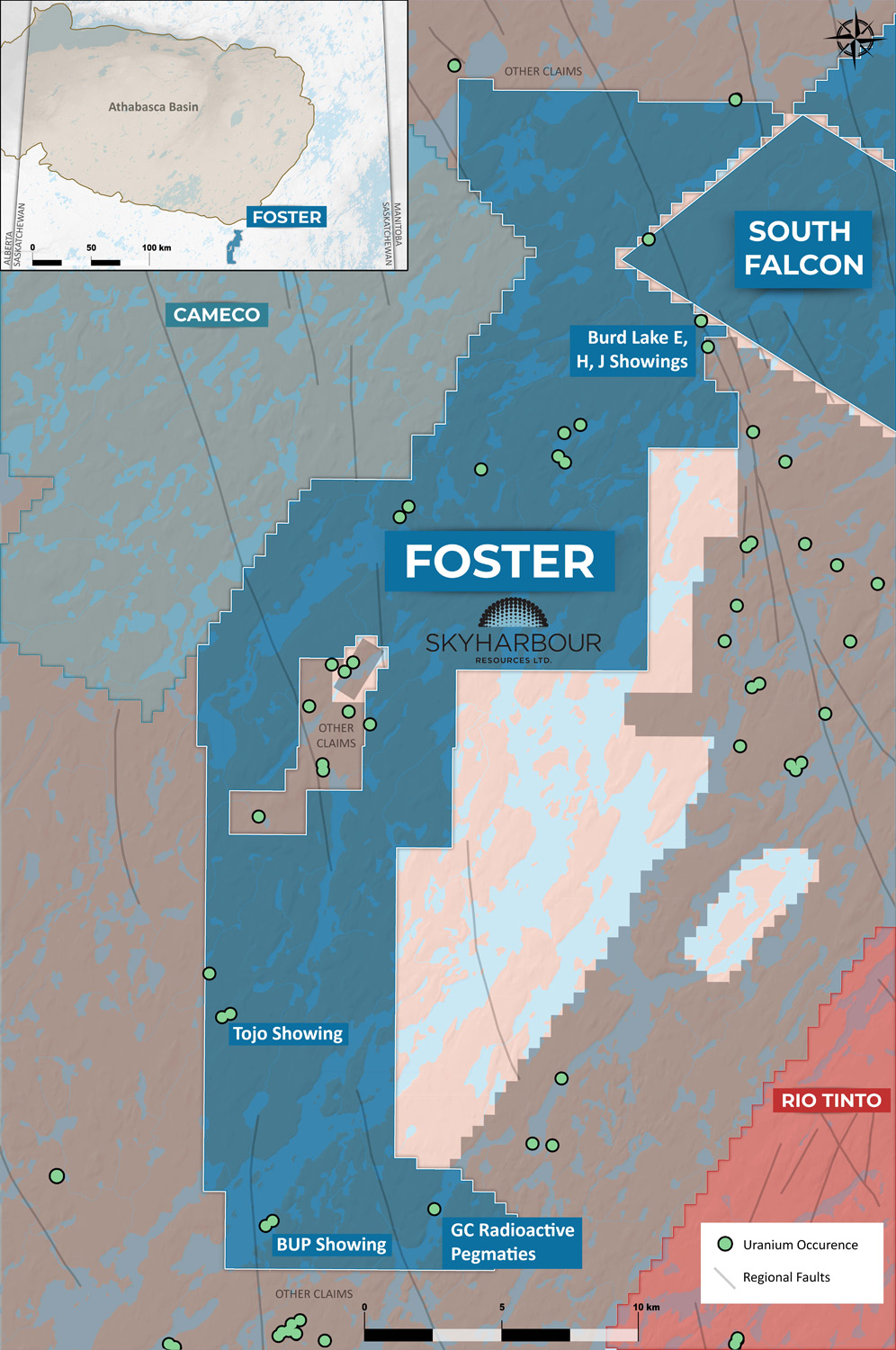
Foster River Project:
The Foster River property consists of seven claims totaling 37,529 hectares approximately 20 km east of Cameco’s Key Lake operation, and adjoining the southwestern end of Skyharbour’s South Falcon Point Project. The claims are situated in the Wollaston Domain just outside of the currently mapped extent of the Athabasca Basin, with several small outliers of sandstone located regionally in the area. The basement geology consists of psammopelite, calc-silicate, diorite, pelitic gneiss and graphitic pelitic gneiss of the Daly Lake Group, accompanied by minor felsic orthogneiss. Prospective graphitic pelitic gneiss packages are exposed at the surface. The property contains numerous uraniferous showings including the Tojo, Burd Lake, and BUP showings, where grab samples returned uranium values ranging from 262 ppm U to 1.25% U3O8 in pitchblende veins. Although historical drilling is limited in the area, a historic hole drilled in the 1950’s returned elevated uranium values of 0.012% U3O8 over 27.7 m. Significant untested potential exists on the Foster River project for basement-hosted, unconformity-related uranium deposits like those further to the north in the Wollaston Domain (i.e. Eagle Point, Rabbit Lake, Key Lake and others).
Foster River Project Map:
https://www.skyharbourltd.com/_resources/maps/Sky_Foster_20211129.jpg
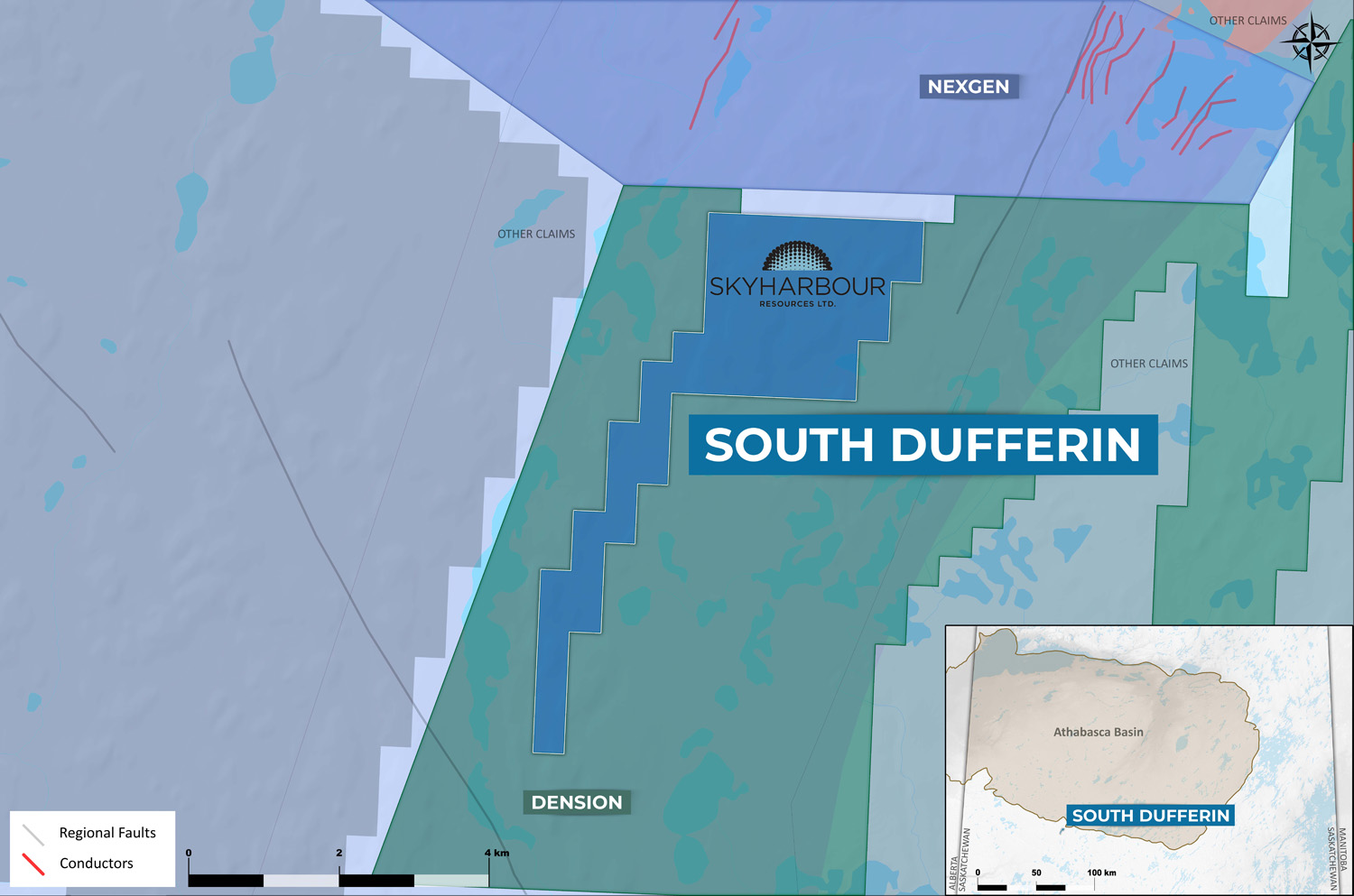
South Dufferin Project:
The property comprises a single claim totaling 922 hectares and lies 13 km south of the Athabasca Basin margin, 32 km south of Cameco’s Centennial deposit and 15 km south of their Dufferin Lake Zone. The property lies within the Snowbird tectonic zone, which is demarcated by the Virgin River Shear Zone. The Virgin River Shear Zone is a fertile uranium corridor, host to numerous zones/showings, the most notable of which are the Centennial Uranium Deposit and the Dufferin Lake Uranium Zone. The basement rocks are comprised of Archean mafic/felsic gneisses of the Taltson domain, which were affected by middle and retrograde amphibolite facies regional metamorphism overprinting granulite facies regional metamorphism. Boulder samples near the property have returned anomalous uranium up to 0.099% U3O8, while anomalous gold mineralization up to 1 g/t was found in outcrop grab samples near the property. Numerous drill-ready targets exist on the property, based upon the results of several high quality airborne gravity and VTEM surveys flown in the 2000’s by JNR Resources.
South Dufferin Project Map:
https://www.skyharbourltd.com/_resources/maps/Sky_SouthDufferin_20211129.jpg
Qualified Person:
The technical information in this news release has been prepared in accordance with the Canadian regulatory requirements set out in National Instrument 43-101 and reviewed and approved by David Billard, P.Geo., a Consulting Geologist for Skyharbour as well as a Qualified Person.
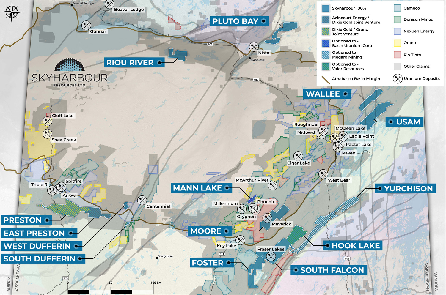
Skyharbour holds an extensive portfolio of uranium exploration projects in Canada’s Athabasca Basin and is well positioned to benefit from improving uranium market fundamentals with fourteen drill-ready projects covering over 385,000 hectares of land. Skyharbour has acquired from Denison Mines, a large strategic shareholder of the Company, a 100% interest in the Moore Uranium Project which is located 15 kilometres east of Denison’s Wheeler River project and 39 kilometres south of Cameco’s McArthur River uranium mine. Moore is an advanced stage uranium exploration property with high grade uranium mineralization at the Maverick Zone that returned drill results of up to 6.0% U3O8 over 5.9 metres including 20.8% U3O8 over 1.5 metres at a vertical depth of 265 metres. The Company is actively advancing the project through drill programs.
Skyharbour has a joint-venture with industry-leader Orano Canada Inc. at the Preston Project whereby Orano has earned a 51% interest in the project through exploration expenditures and cash payments. Skyharbour now owns a 24.5% interest in the Project. Skyharbour also has a joint-venture with Azincourt Energy at the East Preston Project whereby Azincourt has earned a 70% interest in the project through exploration expenditures, cash payments and share issuance. Skyharbour now owns a 15% interest in the Project. Preston and East Preston are large, geologically prospective properties proximal to Fission Uranium’s Triple R deposit as well as NexGen Energy’s Arrow deposit. Furthermore, the Company owns a 100% interest in the South Falcon Point Uranium Project on the eastern perimeter of the Basin, which contains a NI 43-101 inferred resource totaling 7.0 million pounds of U3O8 at 0.03% and 5.3 million pounds of ThO2 at 0.023%.
Skyharbour has several active option partners including: ASX-listed Valor Resources on the Hook Lake Uranium Project whereby Valor can earn-in 80% of the project through CAD $3,500,000 in exploration expenditures, $475,000 in cash payments over three years and an initial share issuance; CSE-listed Basin Uranium Corp. on the Mann Lake Uranium Project whereby Basin Uranium can earn-in 75% of the project through $4,000,000 in exploration expenditures, $850,000 in cash payments as well as share issuances over three years; and CSE-listed Medaro Mining Corp. on the Yurchison Project whereby Medaro can earn-in an initial 70% of the project through $5,000,000 in exploration expenditures, $800,000 in cash payments as well as share issuances over three years followed by the option to acquire the remaining 30% of the project through a payment of $7,500,000 in cash and $7,500,000 worth of shares.
Skyharbour’s goal is to maximize shareholder value through new mineral discoveries, committed long-term partnerships, and the advancement of exploration projects in geopolitically favourable jurisdictions.
Skyharbour’s Uranium Project Map in the Athabasca Basin:
https://www.skyharbourltd.com/_resources/maps/SKY_SaskProject_Locator_20211126.jpg
